Morrison County, Minnesota
A county in Minnesota, ranked 32 of 87 by population.
CountyFIPS 27097
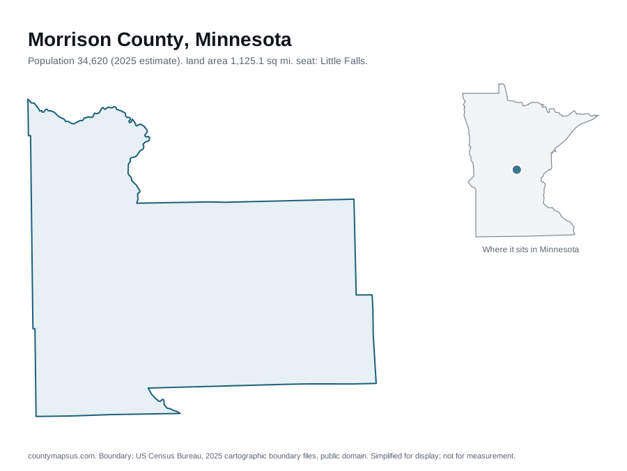
- Population
- 34,620
- +629 (+1.9%) since 2020
- Land area
- 1,125
- square miles. A further 2.5% of the total area is water
- Population density
- 30.8
- people per square mile, computed rather than published
- County seat
- Little Falls
- Seat of county government.
- Established
- 1856
- 169 years ago
- Largest city
- Little Falls city
- Population 9,277.
Sources: US Census Bureau, Population Estimates Program, Vintage 2025 Population Estimates, released 26 March 2026; US Census Bureau, Gazetteer Files, 2025 Gazetteer Files, released 10 September 2025; Wikidata (CC0), Wikidata. Retrieved 30 August 2026.
Satellite view
Aerial imagery of Morrison County with its boundary drawn on top. A map shows you the shape; this shows you what is inside it, and which side of the line a place falls on.
Where Morrison County ranks
Position among the 87 counties of Minnesota, and among all 3,144 US counties and county-equivalents. Computed from the figures on this page.
| Measure | Value | In Minnesota | Nationally |
|---|---|---|---|
| Population | 34,620 | 32nd of 87 | 1,321st of 3,144 |
| Land area | 1,125 sq mi | 17th of 87 | 559th of 3,144 |
| Population density | 30.8 per sq mi | 42nd of 87 | 1,901st of 3,144 |
| Median household income | $69,446 | 71st of 87 | 1,240th of 3,143 |
Full data for Morrison County
| Measure | Value | Source and vintage |
|---|---|---|
| Population | 34,620 | Vintage 2025 Population Estimates |
| Population in 2020 | 33,991 | Vintage 2025 Population Estimates |
| 2020 estimates base? | 34,003 | Vintage 2025 Population Estimates |
| Land area | 1,125 sq mi | 2025 Gazetteer Files |
| Water area | 28.3 sq mi | 2025 Gazetteer Files |
| Total area | 1,153 sq mi | 2025 Gazetteer Files |
| Population density? | 30.8 per sq mi | Computed: Vintage 2025 estimates divided by 2025 Gazetteer land area |
| Median household income | $69,446 | American Community Survey 2020-2024 5-Year Estimates |
| Median home value | $248,500 | American Community Survey 2020-2024 5-Year Estimates |
| Median age | 42.5 | American Community Survey 2020-2024 5-Year Estimates |
| Households | 14,084 | American Community Survey 2020-2024 5-Year Estimates |
| Housing units | 16,256 | American Community Survey 2020-2024 5-Year Estimates |
Sources: US Census Bureau, Population Estimates Program, Vintage 2025 Population Estimates, released 26 March 2026; US Census Bureau, Gazetteer Files, 2025 Gazetteer Files, released 10 September 2025; US Census Bureau, American Community Survey, American Community Survey 2020-2024 5-Year Estimates, released 29 January 2026. Population density is computed here, not published: it divides the Vintage 2025 population estimate by the 2025 Gazetteer land area, which are two different Census products. Retrieved 30 August 2026.
How the population changed
The Census Bureau publishes the components behind an estimate, not just the total. For the year to July 2025:
- Births minus deaths
- +1
- 399 births, 398 deaths
- Net migration
- +124
- More people moved in than moved out.
Source: US Census Bureau, Population Estimates Program, Vintage 2025 Population Estimates, released 26 March 2026. Retrieved 30 August 2026.
The 6 areas bordering Morrison County
Ordered by the length of the border actually shared, which the Census Bureau publishes in its county adjacency file and which no other county reference presents.
| Bordering area | State | Shared border | Population |
|---|---|---|---|
| Todd County | Minnesota | 40 mi | 26,060 |
| Crow Wing County | Minnesota | 38 mi | 69,132 |
| Benton County | Minnesota | 34 mi | 41,744 |
| Mille Lacs County | Minnesota | 25 mi | 27,753 |
| Cass County | Minnesota | 22 mi | 31,430 |
| Stearns County | Minnesota | 18 mi | 164,110 |
Source: US Census Bureau, County Adjacency File, 2025 County Adjacency File, released 15 September 2025. Retrieved 30 August 2026.
All 87 counties of Minnesota
Open the interactive Minnesota county map, or jump straight to any of them.
- Aitkin County
- Anoka County
- Becker County
- Beltrami County
- Benton County
- Big Stone County
- Blue Earth County
- Brown County
- Carlton County
- Carver County
- Cass County
- Chippewa County
- Chisago County
- Clay County
- Clearwater County
- Cook County
- Cottonwood County
- Crow Wing County
- Dakota County
- Dodge County
- Douglas County
- Faribault County
- Fillmore County
- Freeborn County
- Goodhue County
- Grant County
- Hennepin County
- Houston County
- Hubbard County
- Isanti County
- Itasca County
- Jackson County
- Kanabec County
- Kandiyohi County
- Kittson County
- Koochiching County
- Lac qui Parle County
- Lake County
- Lake of the Woods County
- Le Sueur County
- Lincoln County
- Lyon County
- Mahnomen County
- Marshall County
- Martin County
- McLeod County
- Meeker County
- Mille Lacs County
- Morrison County
- Mower County
- Murray County
- Nicollet County
- Nobles County
- Norman County
- Olmsted County
- Otter Tail County
- Pennington County
- Pine County
- Pipestone County
- Polk County
- Pope County
- Ramsey County
- Red Lake County
- Redwood County
- Renville County
- Rice County
- Rock County
- Roseau County
- Scott County
- Sherburne County
- Sibley County
- St. Louis County
- Stearns County
- Steele County
- Stevens County
- Swift County
- Todd County
- Traverse County
- Wabasha County
- Wadena County
- Waseca County
- Washington County
- Watonwan County
- Wilkin County
- Winona County
- Wright County
- Yellow Medicine County
Data on this page last rebuilt 30 August 2026. How these figures are produced.